Marpole
c̓əsnaʔəm | |
|---|---|
Neighbourhood | |
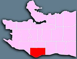
 Location of Marpole in Vancouver. | |
Location in Metro Vancouver | |
| Coordinates: 49°12′56″N 123°06′50″W / 49.215530°N 123.113960°W | |
| Country | |
| Province | British Columbia |
| City | Vancouver |
| Area | |
• Total | 5.59 km2 (2.16 sq mi) |
| Population (2016)[2] | |
• Total | 24,460 |
| • Density | 4,375.6/km2 (11,333/sq mi) |
Marpole, originally a Musqueam village named c̓əsnaʔəm, is a mostly residential neighbourhood of 23,832 in 2011,[3] located on the southern edge of the city of Vancouver, British Columbia, immediately northeast of Vancouver International Airport, and is approximately bordered by Angus Drive to the west, 57th Avenue to the north, Ontario Street to the east and the Fraser River to the south. It has undergone many changes in the 20th century, with the influx of traffic and development associated with the construction of the Oak Street Bridge (which leads to Highway 99 leading to the southern suburbs) and the Arthur Laing Bridge (which leads to Vancouver International Airport).
- ^ "Marpole; Community Statistics" (PDF). vancouver.ca. Government of the City of Vancouver. Retrieved 12 March 2020.
- ^ "Marpole; Community Statistics" (PDF). vancouver.ca. Government of the City of Vancouver. Retrieved 12 March 2020.
- ^ City of Vancouver 2011.
