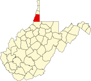
Marshall County | |
|---|---|
 Marshall County Courthouse | |
 Location within the U.S. state of West Virginia | |
 West Virginia's location within the U.S. | |
| Coordinates: 39°52′N 80°40′W / 39.87°N 80.67°W | |
| Country | |
| State | |
| Founded | March 12, 1835 |
| Seat | Moundsville |
| Largest city | Moundsville |
| Area | |
| • Total | 312 sq mi (810 km2) |
| • Land | 305 sq mi (790 km2) |
| • Water | 6.7 sq mi (17 km2) 2.2% |
| Population (2020) | |
| • Total | 30,591 |
| • Estimate (2021) | 30,115 |
| • Density | 98/sq mi (38/km2) |
| Time zone | UTC−5 (Eastern) |
| • Summer (DST) | UTC−4 (EDT) |
| Congressional district | 1st |
| Website | www |
Marshall County is a county in the U.S. state of West Virginia. At the 2020 census, the population was 30,591.[1] Its county seat is Moundsville.[2] With its southern border at what would be a continuation of the Mason-Dixon line to the Ohio River, it forms the base of the Northern Panhandle of West Virginia.
Marshall County is part of the Wheeling metropolitan area.
Marshall County is home to the largest conical burial mound in North America, at Moundsville.[3] Marshall County was formed in 1835[4] from Ohio County by act of the Virginia Assembly. In 1852, on Christmas Eve, workers completed the Baltimore and Ohio Railroad's connection to the Ohio River at Rosby's Rock in Marshall County.[5] It more recently became home to the New Vrindaban community of Hare Krishnas, and Prabhupada's Palace of Gold.
- ^ "State & County QuickFacts". United States Census Bureau. Retrieved October 20, 2022.
- ^ "Find a County". National Association of Counties. Retrieved June 7, 2011.
- ^ "WVDCH-Grave Creek Mound Archaeological Complex". www.wvculture.org. Retrieved March 27, 2018.
- ^ "Archived copy". Archived from the original on September 23, 2001. Retrieved February 4, 2013.
{{cite web}}: CS1 maint: archived copy as title (link) - ^ Marshall County Historical Society. History of Marshall County, West Virginia. Marceline, Mo., Walsworth, 1984.975.416 M367m.
