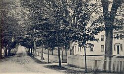
Marshfield Hills, Massachusetts | |
|---|---|
 Highland Street c. 1905 | |
 Location in Plymouth County in Massachusetts | |
| Coordinates: 42°8′40″N 70°43′47″W / 42.14444°N 70.72972°W | |
| Country | United States |
| State | Massachusetts |
| County | Plymouth |
| Area | |
| • Total | 4.94 sq mi (12.78 km2) |
| • Land | 4.58 sq mi (11.87 km2) |
| • Water | 0.35 sq mi (0.91 km2) |
| Elevation | 128 ft (39 m) |
| Population (2020) | |
| • Total | 2,491 |
| • Density | 543.53/sq mi (209.85/km2) |
| Time zone | UTC-5 (Eastern (EST)) |
| • Summer (DST) | UTC-4 (EDT) |
| ZIP code | 02051 |
| Area code | 781 |
| FIPS code | 25-38960 |
| GNIS feature ID | 0615219 |
| Website | www |
Marshfield Hills Historic District | |
 North Community Church and the adjacent cemetery | |
| Location | Bow, Highland, Main, Old Main, Pleasant and Prospect Sts., Glen, Marshfield, Massachusetts |
|---|---|
| Area | 134 acres (54 ha) |
| Architectural style | Colonial, Georgian |
| NRHP reference No. | 09001096[2] |
| Added to NRHP | December 18, 2009 |
Marshfield Hills is a census-designated place (CDP) in the town of Marshfield in Plymouth County, Massachusetts, United States. The population was 2,356 at the 2010 census.[3] The historic center of the village has been designated a historic district and listed on the National Register of Historic Places.[2]
- ^ "2020 U.S. Gazetteer Files". United States Census Bureau. Retrieved May 21, 2022.
- ^ a b "National Register Information System". National Register of Historic Places. National Park Service. July 9, 2010.
- ^ "Profile of General Population and Housing Characteristics: 2010 Demographic Profile Data (DP-1): Marshfield Hills CDP, Massachusetts". United States Census Bureau. Retrieved March 26, 2012.

