23°53′13″S 46°42′50″W / 23.887°S 46.714°W
Marsilac | |
|---|---|
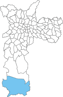
 Location of Marsilac in São Paulo | |
| Country | |
| State | |
| Municipality | |
| Subprefecture | Parelheiros |
| Area | |
• Total | 200 km2 (80 sq mi) |
| Population (2007) | |
• Total | 8,258 |
| • Density | 41/km2 (110/sq mi) |
| Website | Subprefecture of Parelheiros |
Marsilac is one of 96 districts of São Paulo, Brazil, located in the extreme south tip of the city in the subprefecture of Parelheiros.[1] Its name is a tribute to engineer Jose Alfredo Marsilac, who developed many techniques for building roads and tunnels, even after losing 99% of his vision from being hit by a bomb in the Revolution of 1932.
- ^ "Dados Demográficos dos Distritos pertencentes as Subprefeituras". prefeitura.sp.gov.br (in Portuguese). City of São Paulo. Archived from the original on 4 February 2015. Retrieved 28 December 2014.