| Marsili | |
|---|---|
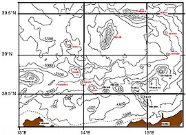
 Aeolian arc, including coastline and depth contour lines for every 500 meters. | |
| Summit depth | −450 m (−1,476 ft) |
| Height | 3,000 m (9,800 ft) |
| Location | |
| Location | Tyrrhenian Sea |
| Coordinates | 39°15′00″N 14°23′40″E / 39.25000°N 14.39444°E |
| Country | Italy |
| Geology | |
| Type | Submarine volcano |
| Volcanic arc/chain | Aeolian Arc |
| Last eruption | 1050 BC ± 200 years[1] |
Marsili is a large undersea volcano in the Tyrrhenian Sea, about 175 kilometers (109 mi) south of Naples. The seamount is about 3,000 m (9,800 feet) tall; its peak and crater are about 450 m below the sea surface. Though it has not erupted in recorded history, volcanologists believe that Marsili is a relatively fragile-walled structure, made of low-density and unstable rocks,[2] fed by the underlying shallow magma chamber. Volcanologists with the Italian National Institute of Geophysics and Volcanology (INGV) announced on March 29, 2010, that Marsili could erupt at any time, and might experience a catastrophic collapse that would suddenly release vast amounts of magma in an undersea eruption and landslide that could trigger destructive tsunamis on the Italian coast and nearby Mediterranean coastlines.[3]
- ^ "IUCN Atlas of the Mediterranean Seamounts. Seamounts and Seamount-Like Structures of the Tyrrhenian Sea" (PDF). Retrieved 31 July 2019.
- ^ Caratori Tontini F., Cocchi L., Muccini F., Carmisciano C., Marani M., Bonatti E., Ligi M., and Boschi E., Potential-field modelling of collapse-prone submarine volcanoes in the Southern Tyrrhenian Sea (Italy), Geophysical Research Letter 37 (2010), L03305, doi:10.1029/2009GL041757.
- ^ "Undersea volcano threatens southern Italy: report". AFP. March 29, 2010. Retrieved August 16, 2014.
