Marton | |
|---|---|
Town | |
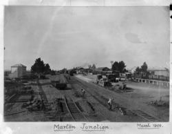
 Marton Junction railway yard and station 1909 | |
 | |
| Coordinates: 40°04′09″S 175°22′42″E / 40.06917°S 175.37833°E | |
| Country | New Zealand |
| Region | Manawatū-Whanganui |
| District | Rangitikei District |
| Wards |
|
| Named for | Marton, England |
| Electorates | |
| Government | |
| • Territorial Authority | Rangitikei District Council |
| • Regional council | Horizons Regional Council |
| Area | |
• Total | 10.99 km2 (4.24 sq mi) |
| Elevation | 152 m (499 ft) |
| Population (June 2024)[2] | |
• Total | 5,740 |
| • Density | 520/km2 (1,400/sq mi) |
| Postcode(s) | 4710 |
| Area code | 06 |
Marton (Māori: Tutaenui) is a town in the Rangitikei district of the Manawatū-Whanganui region of New Zealand's North Island. It is situated 35 kilometres southeast of Whanganui and 40 kilometres northwest of Palmerston North.
Ngāti Apa are tangata whenua for the Marton area.
The town of Marton is the largest in the Rangitikei district, and began life as a private township in 1866, when shop and housing sections were sold at auction by local landowners.
The town had 5,740 residents as of June 2024.[2]
Marton has always been a service town for the fertile farming lands of the lower Rangitikei Rivers flood plains. Butter, wool, and flour have been among its agricultural products. The arrival of the railway in 1878 led to rapid growth in the area, which soon added industries such as engineering, sawmilling, and textile production to its economy.
- ^ Cite error: The named reference
Areawas invoked but never defined (see the help page). - ^ a b "Aotearoa Data Explorer". Statistics New Zealand. Retrieved 26 October 2024.