Marysville, California | |
|---|---|
| City of Marysville | |
|
Top: City Hall (left) and State Theatre (right); bottom: Chinatown (left) and Elks Lodge (right). | |
| Nickname: Gateway to the Gold Fields | |
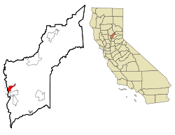
 Location in Yuba County and the state of California | |
| Coordinates: 39°9′N 121°35′W / 39.150°N 121.583°W | |
| Country | United States |
| State | California |
| County | Yuba |
| Incorporated | February 5, 1851[1] |
| Government | |
| • Mayor | Chris Branscum |
| • Vice mayor | Bruce Buttacavolli |
| • City manager | Jim Schaad |
| Area | |
• Total | 3.58 sq mi (9.28 km2) |
| • Land | 3.46 sq mi (8.97 km2) |
| • Water | 0.12 sq mi (0.31 km2) 3.36% |
| Elevation | 62 ft (19 m) |
| Population | |
• Total | 12,844 |
| • Density | 3,600/sq mi (1,400/km2) |
| Time zone | UTC-8 (Pacific) |
| • Summer (DST) | UTC-7 (PDT) |
| ZIP code | 95901 |
| Area code | 530 |
| FIPS code | 06-46170 |
| GNIS feature IDs | 277554, 2411046 |
| Website | www |
Marysville is a city and the county seat of Yuba County, California, located in the Gold Country region of Northern California. As of the 2010 United States Census, the population was 12,072, reflecting a decrease of 196 from the 12,268 counted in the 2000 Census. It is part of the Yuba-Sutter area of Greater Sacramento.
- ^ "California Cities by Incorporation Date". California Association of Local Agency Formation Commissions. Archived from the original (Word) on November 3, 2014. Retrieved August 25, 2014.
- ^ "2019 U.S. Gazetteer Files". United States Census Bureau. Retrieved July 1, 2020.
- ^ "Marysville". Geographic Names Information System. United States Geological Survey, United States Department of the Interior. Retrieved October 17, 2014.
- ^ "US Census Bureau". www.census.gov. Retrieved December 31, 2023.


