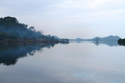
Maskelyne Islands | |
|---|---|
 Maskelynes anchorage | |
 Location of Malakula within Vanuatu | |
| Coordinates: 16°30′S 167°50′E / 16.500°S 167.833°E | |
| Country | |
| Province | Malampa Province |
| Population (2009) | |
• Total | 1,022 |
| Time zone | UTC+11 (VUT) |
The Maskelyne Islands, often abbreviated as the Maskelynes, are a small chain of low islands that forms part of Vanuatu in the Pacific Ocean. Among the islands are Awei, Avock, Leumanang, Uluveo, and Vulai. Uluveo (also called Maskelyne) is the main island in the group and has three villages.[1]
The islands lie at the southeastern end of Malakula, which is the second-largest island in the nation of Vanuatu. They were named by Captain Cook after the Astronomer Royal Nevil Maskelyne as he sailed north from Port Resolution on Tanna in HMS Resolution in late 1774.[2]
- ^ "The Maskelyne Islands, South Malekula". Positive Earth. Retrieved 10 August 2018.
- ^ "A Cruising Sailor Gets Up Close and Personal". Cruising World. 11 May 2007. Retrieved 3 December 2011.