Massanutten, Virginia | |
|---|---|
 | |
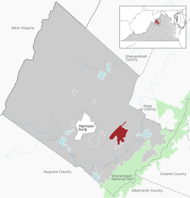
 Location of the Massanutten CDP within the Rockingham County | |
| Coordinates: 38°24′16″N 78°44′24″W / 38.40444°N 78.74000°W | |
| Country | United States |
| State | Virginia |
| County | Rockingham |
| Area | |
| • Total | 14.3 sq mi (37.1 km2) |
| • Land | 14.3 sq mi (37.1 km2) |
| • Water | 0.0 sq mi (0.0 km2) |
| Elevation | 1,699 ft (518 m) |
| Population (2010) | |
| • Total | 2,291 |
| • Density | 160/sq mi (62/km2) |
| Time zone | UTC−5 (Eastern (EST)) |
| • Summer (DST) | UTC−4 (EDT) |
| ZIP code | 22840 |
| Area code | 540 |
| FIPS code | 51-50030[1] |
| GNIS feature ID | 1867594[2] |
Massanutten is a census-designated place (CDP) in Rockingham County, Virginia, United States, built around a ski resort. The population was 2,291 at the 2010 census. It is part of the Harrisonburg Metropolitan Statistical Area.
- ^ "U.S. Census website". United States Census Bureau. Retrieved 2008-01-31.
- ^ "US Board on Geographic Names". United States Geological Survey. 2007-10-25. Retrieved 2008-01-31.
