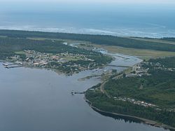
Masset | |
|---|---|
| Village of Masset[1] | |
 | |
Location of Masset in British Columbia | |
| Coordinates: 54°00′36″N 132°08′17″W / 54.01000°N 132.13806°W | |
| Country | Canada |
| Province | British Columbia |
| Region | Haida Gwaii |
| Regional district | North Coast |
| Incorporated | 1961 |
| Government | |
| • Governing body | Masset Village Council |
| • Mayor | Barry Pages |
| Area | |
| • Total | 19.45 km2 (7.51 sq mi) |
| Elevation | 10 m (30 ft) |
| Population (2016)[2] | |
| • Total | 793 |
| • Density | 41/km2 (110/sq mi) |
| Time zone | UTC−8 (PST) |
| • Summer (DST) | UTC-7 (PDT) |
| Highways | |
| Waterways | Dixon Entrance |
| Website | massetbc |
Masset (/ˈmæsɪt/; formerly Massett)[3] is a village in the Haida Gwaii archipelago in British Columbia, Canada. It is located on Masset Sound on the northern coast of Graham Island, the largest island in the archipelago, and is approximately 50 km (31 mi) west of mainland British Columbia. It is the primary western terminus of Trans-Canada Highway 16 (the Yellowhead Highway) and is served by Masset Airport, with flights to Vancouver and Prince Rupert. During the maritime fur trade of the early 19th century, Masset was a key trading site. It was incorporated as a village municipality on May 11, 1961.[4]
- ^ "British Columbia Regional Districts, Municipalities, Corporate Name, Date of Incorporation and Postal Address" (XLS). British Columbia Ministry of Communities, Sport and Cultural Development. Archived from the original on July 13, 2014. Retrieved November 2, 2014.
- ^ Statistics Canada. 2016 Census
- ^ "Masset". BC Geographical Names.
- ^ BC Names entry "Masset (Village)"

