Matagorda County | |
|---|---|
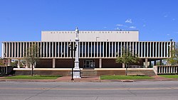
 The Matagorda County Courthouse and Confederate Soldier Statue in Bay City | |
 Location within the U.S. state of Texas | |
 Texas's location within the U.S. | |
| Coordinates: 28°47′N 96°00′W / 28.78°N 96°W | |
| Country | |
| State | |
| Founded | 1836 |
| Seat | Bay City |
| Largest city | Bay City |
| Area | |
• Total | 1,613 sq mi (4,180 km2) |
| • Land | 1,100 sq mi (3,000 km2) |
| • Water | 512 sq mi (1,330 km2) 32% |
| Population (2020) | |
• Total | 36,255 |
| • Density | 22/sq mi (8.7/km2) |
| Time zone | UTC−6 (Central) |
| • Summer (DST) | UTC−5 (CDT) |
| Congressional district | 22nd |
| Website | www |

Matagorda County is a county located in the U.S. state of Texas. As of the 2020 census, the population was 36,255.[1] Its county seat is Bay City,[2] not to be confused with the larger Baytown in Harris and Chambers Counties. Matagorda County is named for the canebrakes that once grew along the coast (matagorda is a Spanish word meaning "thick bush").
Matagorda County comprises the Bay City, TX Micropolitan Statistical Area, which is also included in the Houston-The Woodlands, TX combined statistical area.
- ^ "Matagorda County, Texas". United States Census Bureau. Retrieved February 23, 2021.
- ^ "Find a County". National Association of Counties. Retrieved June 7, 2011.