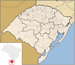
Mato Queimado | |
|---|---|
 Location in Rio Grande do Sul state | |
| Coordinates: 28°15′21″S 54°36′57″W / 28.25583°S 54.61583°W | |
| Country | Brazil |
| Region | South |
| State | Rio Grande do Sul |
| Mesoregion | Noroeste Rio-Grandense |
| Microregion | Cerro Largo |
| Area | |
| • Total | 114.64 km2 (44.26 sq mi) |
| Population (2020 [1]) | |
| • Total | 1,629 |
| • Density | 14/km2 (37/sq mi) |
| Time zone | UTC−3 (BRT) |
| Website | matoqueimado |
Mato Queimado is a Brazilian municipality located in the northwestern part of the state of the Rio Grande do Sul. The population is about 1,629 (2020 est.) in an area of 114.64 km².[2] It is located 489 km in the west of the state capital of Porto Alegre and northeast of Alegrete.

