| Mauritania Railway | ||||||||||||||||||||||||||||||||||||||||||||||||||||||||||||||||||||||||||||||||||||||||||||||||||||||||||||||||||||||||||||||||||||||||||||||||||||||||||||||||
|---|---|---|---|---|---|---|---|---|---|---|---|---|---|---|---|---|---|---|---|---|---|---|---|---|---|---|---|---|---|---|---|---|---|---|---|---|---|---|---|---|---|---|---|---|---|---|---|---|---|---|---|---|---|---|---|---|---|---|---|---|---|---|---|---|---|---|---|---|---|---|---|---|---|---|---|---|---|---|---|---|---|---|---|---|---|---|---|---|---|---|---|---|---|---|---|---|---|---|---|---|---|---|---|---|---|---|---|---|---|---|---|---|---|---|---|---|---|---|---|---|---|---|---|---|---|---|---|---|---|---|---|---|---|---|---|---|---|---|---|---|---|---|---|---|---|---|---|---|---|---|---|---|---|---|---|---|---|---|---|---|
 Map of Mauritania Railway | ||||||||||||||||||||||||||||||||||||||||||||||||||||||||||||||||||||||||||||||||||||||||||||||||||||||||||||||||||||||||||||||||||||||||||||||||||||||||||||||||
| Technical | ||||||||||||||||||||||||||||||||||||||||||||||||||||||||||||||||||||||||||||||||||||||||||||||||||||||||||||||||||||||||||||||||||||||||||||||||||||||||||||||||
| Line length | 704 km (437 mi) | |||||||||||||||||||||||||||||||||||||||||||||||||||||||||||||||||||||||||||||||||||||||||||||||||||||||||||||||||||||||||||||||||||||||||||||||||||||||||||||||
| Track gauge | 1,435 mm (4 ft 8+1⁄2 in) standard gauge | |||||||||||||||||||||||||||||||||||||||||||||||||||||||||||||||||||||||||||||||||||||||||||||||||||||||||||||||||||||||||||||||||||||||||||||||||||||||||||||||
| ||||||||||||||||||||||||||||||||||||||||||||||||||||||||||||||||||||||||||||||||||||||||||||||||||||||||||||||||||||||||||||||||||||||||||||||||||||||||||||||||
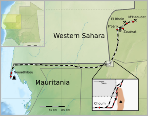
The Mauritania Railway is the national railway of Mauritania. Construction of the line began in 1960, with its opening in 1963.[1][2] It consists of a single, 704-kilometre (437 mi) railway line linking the iron mining center of Zouérat with the port of Nouadhibou, via Fderik and Choum. The state agency Société nationale industrielle et minière (SNIM) controls the railway line.
Since the closure of the Choum Tunnel, a 5 km (3.1 mi) section of the railway cuts through the Polisario Front-controlled part of the Western Sahara (21°21′18″N 13°00′46″W / 21.354867°N 13.012644°W).
- ^ "Mauritania, a Nation of Moorish Nomads, Suddenly Finds Herself in 20th Century". The New York Times. January 20, 1964.
last June, the 20th century elbowed its way into this Biblical picture
- ^ Pazzanita, Anthony G. (2008). Historical Dictionary of Mauritania. Scarecrow Press. pp. 424–25. ISBN 9780810862654. Retrieved 25 January 2020.