A request that this article title be changed to 2009 Super Derecho is under discussion. Please do not move this article until the discussion is closed. |
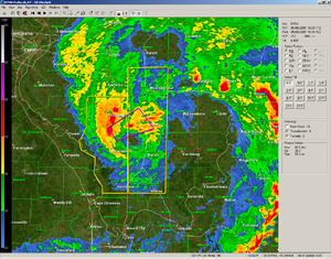
 A screenshot from the Paducah, Kentucky, radar of the mesoscale convective vortex portion of the derecho near Carbondale, Illinois. This screenshot is from the approximate time the 106 mph (171 km/h) wind gust was recorded at the Southern Illinois Airport. | |
| Date(s) | May 8, 2009 |
|---|---|
| Duration | 15 hours, 28 minutes (tornado outbreak) |
| Tornado count | 39 confirmed[1][2][3] |
| Strongest tornado1 | EF3 tornado |
| Fatalities | Four direct, two indirect[4][5][6][7] |
| Damage costs | ~$500 million[8] |
| 1Most severe tornado damage; see Fujita scale | |
The May 2009 Southern Midwest Derecho was an extreme progressive derecho and mesoscale convective vortex (MCV) event that struck southeastern Kansas, southern Missouri, and southwestern Illinois on May 8, 2009.[9][10] Thirty-nine tornadoes, including two of EF3 strength on the Enhanced Fujita Scale, were reported in addition to high non-tornadic winds associated with the derecho and MCV.[10] Due to the abnormal shape of the storm on radar and the extremely strong winds, many called this an "inland hurricane."[11][12] A new class of storm, the Super Derecho, has been used to describe this event after analysis in 2010.[13] Embedded supercells produced hail up to baseball size in southern Missouri, a rare event in a derecho.[2] A wind gust of 106 mph (171 km/h) was recorded by a backup anemometer at the Southern Illinois Airport after official National Weather Service equipment failed.[1] This derecho was the last of a series of derechos that occurred at the beginning of May.
- ^ a b "Updated: What was it that caused the May 8 windstorm?". National Weather Service Paducah, KY. May 19, 2009. Retrieved June 29, 2009.
- ^ a b Cite error: The named reference
lsxsummarywas invoked but never defined (see the help page). - ^ Cite error: The named reference
sgfsummarywas invoked but never defined (see the help page). - ^ Novara, Chuck (May 9, 2009). "Friday's Storms Claim One". Marion, Illinois: The Southern Illinoisan. Retrieved April 10, 2010.
- ^ "One storm related death reported in the four states". Wilson County, Kansas: KOAM. May 11, 2009. Retrieved June 29, 2009.
- ^ Cite error: The named reference
wkytrichmondtorwas invoked but never defined (see the help page). - ^ Cite error: The named reference
hutchnewswas invoked but never defined (see the help page). - ^ Stuart Hinson (2009). "NCDC Storm Events Database". National Climatic Data Center. Archived from the original on May 5, 2011. Retrieved September 5, 2009.
- ^ Corfidi, Stephen. "The "Super Derecho" of May 2009". NOAA.
- ^ Skilling, Tom (May 11, 2009). "Today's Ask Tom Why". WGN-TV. Archived from the original on July 18, 2011. Retrieved April 7, 2010.
- ^ Some residents of southern Illinois, in the tradition of giving female names to hurricanes, informally dubbed this storm "Ada May", in commemoration of its date, "eight o' May." Amos, Dawn. "Report from Southern Illinois after severe storms".
- ^ Israel, Brett (12 September 2010). "Huge Windstorm Spawns New Classification: 'Super Derecho'". Imaginova Corporation. LiveScience. Retrieved 19 September 2010.