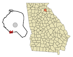
Maysville, Georgia | |
|---|---|
 Location in Banks County and the state of Georgia | |
| Coordinates: 34°15′20″N 83°33′08″W / 34.25556°N 83.55222°W | |
| Country | United States |
| State | Georgia |
| Counties | Banks, Jackson |
| Area | |
| • Total | 4.72 sq mi (12.22 km2) |
| • Land | 4.66 sq mi (12.06 km2) |
| • Water | 0.06 sq mi (0.16 km2) |
| Elevation | 889 ft (271 m) |
| Population (2020) | |
| • Total | 1,867 |
| • Density | 400.99/sq mi (154.83/km2) |
| Time zone | UTC-5 (Eastern (EST)) |
| • Summer (DST) | UTC-4 (EDT) |
| ZIP code | 30558 |
| Area code | 706 |
| FIPS code | 13-50484[3] |
| GNIS feature ID | 2406117[2] |
| Website | cityofmaysvillega |
Maysville is a town in Banks and Jackson counties in the U.S. state of Georgia. The population was 1,798 at the 2010 census,[4] up from 1,247 at the 2000 census.
- ^ "2020 U.S. Gazetteer Files". United States Census Bureau. Retrieved December 18, 2021.
- ^ a b U.S. Geological Survey Geographic Names Information System: Maysville, Georgia
- ^ "U.S. Census website". United States Census Bureau. Retrieved January 31, 2008.
- ^ "Geographic Identifiers: 2010 Demographic Profile Data (G001): Maysville town, Georgia". U.S. Census Bureau, American Factfinder. Archived from the original on February 12, 2020. Retrieved October 29, 2013.
