| Mayurakshi River Mor River | |
|---|---|
 Mayurakshi River in its upper reaches | |
 | |
| Location | |
| Country | India |
| State | Jharkhand, West Bengal |
| Cities | Dumka, Suri, Sainthia, Bhandirban |
| Physical characteristics | |
| Source | Trikut Hill |
| • location | Deoghar, Jharkhand |
| • coordinates | 24°29′00″N 86°42′0″E / 24.48333°N 86.70000°E |
| Length | 250 km (160 mi) |
| Discharge | |
| • location | Hooghly River |
| Basin features | |
| Tributaries | |
| • right | Kopai, Brahmani, Dwaraka, Bakreshwar |

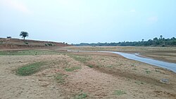
The Mayurakshi (also called Mor River) is a major river in Jharkhand and West Bengal, India, with a long history of devastating floods.
It has its source on Trikut Hills, about 16 kilometres (10 mi) from Deoghar in Jharkhand state.[1] The Mayurakshi flows through Jharkhand and then through the districts of Birbhum and Murshidabad in West Bengal before flowing into the Hooghly River. The river is about 250 kilometres (160 mi) long.[2]
Mayurakshi literally means "peacock eyes" (mayur/mor=peacock, akshi=eye). The comparison is with the beautiful feathers on a peacock's tail. Though named after its crystal clear water in the dry season, the Mayurakshi floods its valley during the monsoons. Even after the construction of the Massanjore dam, it floodwaters continue to wreak havoc, washing away embankments.
- ^ "Incredible India". Baidyanathdham (Deoghar). India Tourism. Archived from the original on 2007-01-11. Retrieved 2007-02-19.
- ^ Selim. Mohammad, Irrigation Projects in Birbhum District, published in Paschim Banga, February 2006, (in Bengali), Birbhum special issue, Govt. of West Bengal, p 168-169