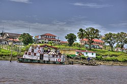
| Mazaruni River | |
|---|---|
 | |
 | |
| Location | |
| Country | Guyana |
| Physical characteristics | |
| Source | |
| • location | Pakaraima Mountains, Guyana |
| • coordinates | 5°36′50.22″N 59°57′19.4292″W / 5.6139500°N 59.955397000°W |
| • elevation | 870 m (2,850 ft) |
| Mouth | Cuyuni |
• coordinates | 6°22′50.4264″N 58°41′6.0612″W / 6.380674000°N 58.685017000°W |
• elevation | 1 m (3 ft 3 in) |
| Length | 560 km (350 mi) |
| Basin size | 31,704.8 km2 (12,241.3 sq mi)[1] |
| Discharge | |
| • location | Near mouth |
| • average | (Period: 1971–2000)1,398.7 m3/s (49,390 cu ft/s)[1] |
| Basin features | |
| Progression | Cuyuni → Essequibo → Atlantic Ocean |
| Tributaries | |
| • left | Haieka, Kako, Kukui, Kamarang, Puruni |
| • right | Kurupung, Merume, Karanang, Semang, Issano, Kaburi |

The Mazaruni River is a tributary of the Essequibo River in northern Guyana. Its source is in the remote western forests of the Pakaraima Mountains and its confluence with the Cuyuni River is near Bartica. As it descends from the Guiana Highlands the river runs south-east, past Issano, then northward to Bartica. The river is a source of alluvial gold.