Mazraat es-Siyyed
ܕܝܪܐ ܥܘܙܐ | مزرعة السياد | |
|---|---|
 | |
| Coordinates: 34°6′15″N 35°51′35″E / 34.10417°N 35.85972°E | |
| Country | |
| Governorate | Keserwan-Jbeil |
| District | Byblos |
| Government | |
| • Mayor | Robert Tony Gharios |
| Area | |
| • Total | 7.91 km2 (3.05 sq mi) |
| Highest elevation | 1,250 m (4,100 ft) |
| Time zone | UTC+2 (EET) |
| • Summer (DST) | UTC+3 (EEST) |
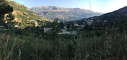
Mazraat es-Siyed (Arabic: مزرعة السياد; also transliterated Mazraet es-Siyed, Mazraet el-Siyed, pronounced [Mazraʿat Essiyyèd]) is a mountainous village in the highlands of the Byblos District in the Keserwan-Jbeil Governorate, Lebanon. The town is 58 kilometres (36 mi) away from Beirut, and stands at an elevation of 1,250 m (4,100 ft) above sea level.[1]
- ^ Localiban (15 June 2015). "Mazraat Es Siyad". Localiban, Administrative Divisions of Lebanon. Data Center on Local Development in Lebanon. Archived from the original on 20 March 2023. Retrieved 9 July 2015.
