McFarland, California | |
|---|---|
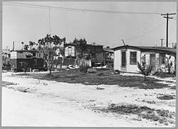
 McFarland in 1940 | |
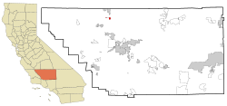
 Location in Kern County and the state of California | |
| Coordinates: 35°40′41″N 119°13′45″W / 35.67806°N 119.22917°W | |
| Country | |
| State | |
| County | Kern |
| Founded | 1909 |
| Incorporated | July 18, 1957[1] |
| Named for | James Boyd McFarland |
| Government | |
| • Mayor | Saul Ayon[2] |
| • State Senator | Anna Caballero (D)[3] |
| • State Assembly | Jasmeet Bains (D)[4] |
| • U. S. Congress | David Valadao (R)[5] |
| Area | |
• Total | 2.67 sq mi (6.91 km2) |
| • Land | 2.67 sq mi (6.91 km2) |
| • Water | 0.00 sq mi (0.00 km2) 0% |
| Elevation | 354 ft (108 m) |
| Population (2020) | |
• Total | 14,161 |
| • Density | 6,476.86/sq mi (2,500.69/km2) |
| Time zone | UTC-8 (PST) |
| • Summer (DST) | UTC-7 (PDT) |
| ZIP code | 93250 |
| Area code | 661 |
| FIPS code | 06-44826 |
| GNIS feature IDs | 1652750, 2411062 |
| Website | www |
McFarland (formerly, Hunt and Lone Pine)[8] is a city in the San Joaquin Valley, in Kern County, California, United States. McFarland is located 25 miles (40 km) north-northwest of Bakersfield and 6.5 miles (10 km) south of Delano,[8] at an elevation of 354 feet (108 m).[7] The population of McFarland was 12,707 at the 2010 census[9] and an estimated 15,506 as of 2019.
- ^ "California Cities by Incorporation Date". California Association of Local Agency Formation Commissions. Archived from the original (Word) on November 3, 2014. Retrieved April 12, 2013.
- ^ "Mayor & City Council". McFarland, CA. Retrieved July 15, 2023.
- ^ "Senators". State of California. Retrieved April 12, 2013.
- ^ "Members Assembly". State of California. Retrieved April 12, 2013.
- ^ "California's 22nd Congressional District - Representatives & District Map". Civic Impulse, LLC. Retrieved April 12, 2013.
- ^ "2019 U.S. Gazetteer Files". United States Census Bureau. Retrieved July 1, 2020.
- ^ a b "McFarland". Geographic Names Information System. United States Geological Survey, United States Department of the Interior.
- ^ a b Durham, David L. (1998). California's Geographic Names: A Gazetteer of Historic and Modern Names of the State. Clovis, Calif.: Word Dancer Press. p. 1069-1070. ISBN 1-884995-14-4.
- ^ "Geographic Identifiers: 2010 Demographic Profile Data (G001): McFarland city, California". U.S. Census Bureau, American Factfinder. Retrieved January 24, 2019.[dead link]
