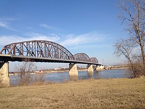
McKinley Bridge | |
|---|---|
 | |
| Coordinates | 38°39′54″N 90°10′58″W / 38.66500°N 90.18278°W |
| Carries | 1 dedicated service lane, 2 lanes of traffic, and 1 dedicated pedestrian/bicycle lane |
| Crosses | Mississippi River |
| Locale | St. Louis, Missouri and Venice, Illinois |
| Maintained by | Illinois Department of Transportation |
| Characteristics | |
| Design | Steel truss bridge |
| Total length | 6,313 feet (1,924 m) |
| Longest span | Three - 519 feet (158 m) spans |
| Clearance below | 90 feet (27 m) |
| History | |
| Opened | November 10, 1910 Pedestrian re-opening: November 17, 2007 Full re-opening: December 17, 2007 |
| Statistics | |
| Daily traffic | 17,000 (2014)[1] |
| Location | |
 | |
The McKinley Bridge is a steel truss bridge across the Mississippi River. It connects northern portions of the city of St. Louis, Missouri with Venice, Illinois. It opened in 1910 and was taken out of service on October 30, 2001. The bridge was reopened for pedestrian and bicyclists on November 17, 2007 with a grand re-opening celebration.[2] Since December 2007, McKinley has been open to vehicular traffic as well. It is accessible from Illinois Route 3 in Illinois and from the intersection of Salisbury and North 9th Street in the city of St. Louis. The bridge carried both railroad and vehicular traffic across the Mississippi River for decades. By 1978, the railroad line over the span was closed, and an additional set of lanes was opened for vehicles in the inner roadway.
The McKinley Bridge was the first alignment of U.S. Route 66 across the Mississippi. It is commonly assumed that the bridge was named for President William McKinley; but in reality, it was named for the builder, William B. McKinley, chief executive of the Illinois Traction System interurban electric railway, which accessed St. Louis via the bridge.
- ^ "IDOT: New bridge carrying less traffic than originally expected". Belleville News Democrat. April 14, 2014. Archived from the original on July 14, 2014. Retrieved July 5, 2014.
- ^ St. Amand, Amanda (October 21, 2007). "Be thankful: Next month, we'll have McKinley back". St. Louis Post-Dispatch. Archived from the original on November 22, 2007. Retrieved October 22, 2007.