| McKittrick Canyon | |
|---|---|
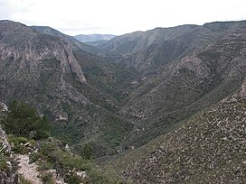
 South McKittrick Canyon from the Notch | |
 Map of McKittrick Canyon and hiking trails | |
| Floor elevation | 4,997 feet (1,523 m)[1] |
| Long-axis direction | East-West |
| Area | 5,632 acres (2,279 ha)[2] |
| Depth | 3,200 feet (980 m) |
| Geology | |
| Age | 12 million years[2] |
| Geography | |
| Location | Culberson County, Texas, and Eddy County, New Mexico, United States |
| Coordinates | 31°58′45″N 104°45′17″W / 31.979167°N 104.754722°W [1] |
| Topo map | USGS Guadalupe Peak, El Paso Gap |
| Traversed by | McKittrick Canyon Trail |
| Rivers | |
McKittrick Canyon Archeological District, Guadalupe Mountains National Park | |
| Location | Address restricted[4] |
| Nearest city | Salt Flat, Texas |
| Area | 411 acres (166 ha) |
| NRHP reference No. | 91001381[3] |
| Added to NRHP | September 26, 1991 |
McKittrick Canyon is a scenic canyon within the Guadalupe Mountains of West Texas and Eddy County, New Mexico. The steep, towering walls of McKittrick Canyon protect a rich riparian oasis in the midst of the Chihuahuan Desert.
The majority of McKittrick Canyon is part of Guadalupe Mountains National Park, but is separated from the main park area and managed as a day-use only area with limited visitation hours.[2] A large part of North McKittrick Canyon, though, is located in the Guadalupe Ranger District of Lincoln National Forest in New Mexico. Access to McKittrick Canyon is by a 4.2-mile (6.8-km) gated side road that leads to the mouth of McKittrick Canyon from U.S. Route 62/180. Here, the National Park Service maintains a parking area, restroom facilities, and visitor center, which is staffed most of the year by volunteers.
- ^ a b "McKittrick Canyon". Geographic Names Information System. United States Geological Survey, United States Department of the Interior.
- ^ a b c "McKittrick Canyon". Guadalupe Mountains National Park. US National Park Service. Retrieved March 3, 2013.
- ^ "National Register Information System". National Register of Historic Places. National Park Service. July 9, 2010.
- ^ Federal and state laws and practices restrict general public access to information regarding the specific location of this resource. In some cases, this is to protect archeological sites from vandalism, while in other cases it is restricted at the request of the owner. See: Knoerl, John; Miller, Diane; Shrimpton, Rebecca H. (1990), Guidelines for Restricting Information about Historic and Prehistoric Resources, National Register Bulletin, National Park Service, U.S. Department of the Interior, OCLC 20706997.