McMillin Bridge | |
|---|---|
 | |
| Coordinates | 47°07′47″N 122°14′09″W / 47.1297227°N 122.2359037°W |
| Carries | |
| Crosses | Puyallup River |
| Locale | Pierce County, Washington |
| Characteristics | |
| Design | Concrete half-through truss bridge |
| Longest span | 170 feet (52 m) |
| History | |
| Opened | 1934 |
McMillin Bridge | |
 | |
| Nearest city | Puyallup, Washington |
| Architect | Homer M. Hadley, W. H. Witt Co. |
| MPS | Historic Bridges/Tunnels in Washington State TR |
| NRHP reference No. | 82004275[1] |
| Added to NRHP | July 16, 1982 |
| Location | |
 | |
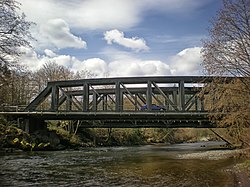
The McMillin Bridge (also known as the Puyallup River Bridge[2]) is a concrete half-through truss bridge crossing the Puyallup River, in Pierce County, Washington, built in 1934.
The main span of the bridge is 170 feet (52 m) long, which was the longest beam span or concrete truss in the US when it was built. It was part of State Route 162 until it was replaced by a new span in 2015.
- ^ "National Register Information System". National Register of Historic Places. National Park Service. January 23, 2007.
- ^ "Historic Bridges". Retrieved February 20, 2008.