Menchukha
Menchukha | |
|---|---|
Town | |
 Arunachal Pradesh, India | |
| Coordinates: 28°36′18″N 94°7′41″E / 28.60500°N 94.12806°E | |
| Country | |
| State | Arunachal Pradesh |
| District | Shi-Yomi district |
| Elevation | 2,000 m (7,000 ft) |
| Languages | |
| • Official | Hindi, English |
| Time zone | UTC+05:30 (IST) |
| ISO 3166 code | IN-AR |
| Vehicle registration | AR |

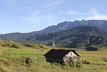
Mechukha or Menchukha (In Memba dialect, 'Men' means Medicine, 'Chu' means Water -streams, rivers, etc. & 'Kha' means Snow; Meaning "the land blessed with medicinal snow-fed water- river & streams") is a town, assembly constituency and subdivision, situated 6,000 feet (1,829 m) above sea level in the Mechukha Valley of Yargep Chu/ Siyom River in Shi Yomi district of Arunachal Pradesh state of India.[1] Before the 1950s, Mechuka valley was known as Pachakshiri.[2]
Line of Actual Control (McMahon Line) India-Tibet border 29 km north of Menchuka separates Indian territory and Chinese territory.[3] Mechukha has a AGL airstrip. Reachable by one of the strategic India-China Border Roads, it is located 47 km northwest of district head office Tato and 187 km north of Aalo.
- ^ "Basar MLA". Archived from the original on 19 August 2016. Retrieved 22 October 2016.
- ^ Grothmann, Kerstin (26 November 2020). Pachakshiri: A Little-Known Hidden Land between Tsa ri and Padma bkod in the Eastern Himalaya. Brill. p. 276. ISBN 978-90-04-43768-5.
- ^ "The last village in our arunachal". Retrieved 1 August 2017.

