Meeanee | |
|---|---|
Suburb of Napier | |
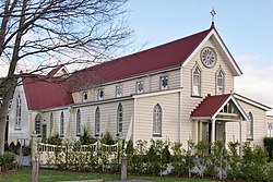
 St. Mary's Church, Meeanee. | |
 | |
| Coordinates: 39°32′38″S 176°53′35″E / 39.544°S 176.893°E | |
| Country | New Zealand |
| Region | Hawke's Bay |
| Territorial authority | Napier City |
| Ward | Taradale |
| Named for | Battle of Meeanee[1] |
| Electorates | |
| Government | |
| • Territorial Authority | Napier City Council |
| • Regional council | Hawke's Bay Regional Council |
| Area | |
• Total | 24.17 km2 (9.33 sq mi) |
| Elevation | 0–3 m (0–10 ft) |
| Population (June 2024)[3] | |
• Total | 3,830 |
| • Density | 160/km2 (410/sq mi) |
| Time zone | UTC+12 (NZST) |
| • Summer (DST) | UTC+13 (NZDT) |
| Postcode | 4112 |
| Area Code | 06 |
Meeanee is a locality south of the city of Napier, in the Hawke's Bay Region on the east coast of New Zealand's North Island. It was named after the Battle of Meeanee in India (now spelled Miani, but the area has retained the older spelling), won by Sir Charles Napier, the city's namesake.[1] Along with such locations as Clive and Havelock North, it is one of several places within Hawke's Bay to be named after events or people in Colonial India.
- ^ a b "St Thomas' Anglican Church". Heritage New Zealand. Retrieved 8 December 2019.
- ^ Cite error: The named reference
Areawas invoked but never defined (see the help page). - ^ "Aotearoa Data Explorer". Statistics New Zealand. Retrieved 26 October 2024.