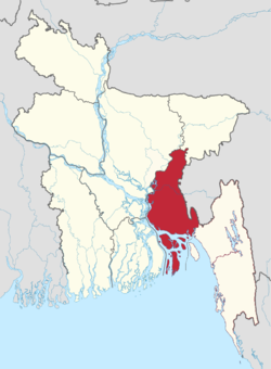
Cumilla Division
কুমিল্লা বিভাগ | |
|---|---|
 | |
| Coordinates: 23°27′N 91°12′E / 23.450°N 91.200°E | |
| Country | |
| Capital and largest city | Comilla |
| Area | |
• Total | 12,848.53 km2 (4,960.85 sq mi) |
| Population (2011 census) | |
• Total | 16,918,446 |
| • Density | 1,300/km2 (3,400/sq mi) |
| Time zone | UTC+6 (BST) |
| ISO 3166 code | BD-B |
| Main Language(s) | Bengali |
| Other languages | English |
| Districts | 6 |
| upazilas | 59 |
Cumilla Division (Bengali: কুমিল্লা বিভাগ) was a proposed administrative division within Bangladesh for the north-western parts of the existing Chittagong Division,[1] comprising Brahmanbaria, Comilla, Chandpur, Noakhali, Feni, and Laxmipur Districts of Chittagong Division.[2][3][4][5] The headquarter of the division would be in Comilla. It covers the south-easternmost areas of the country, with a total area of 12,848.53 km2 (4,960.85 sq mi)[6] and a population at the 2011 census of 16,708,000.[7][8][9]
- ^ কুমিল্লা বিভাগ দ্রুত বাস্তবায়নের দাবি [Cumilla Division demanded quick implementation]. Prothom Alo (in Bengali). Retrieved 16 February 2015.
- ^ প্রতিবেদক, নিজস্ব; ডটকম, বিডিনিউজ টোয়েন্টিফোর. "কুমিল্লা বিভাগের নাম হবে 'ময়নামতি'". bangla.bdnews24.com (in Bengali).
- ^ ময়মনসিংহ বিভাগ গঠনে কাজ শুরুর নির্দেশ প্রধানমন্ত্রীর [Mymensingh Division worked on the instruction of the Prime Minister]. Prothom Alo (in Bengali). Retrieved 26 January 2015.
- ^ "Mymensingh to become new division". The Daily Star. 26 January 2015. Retrieved 26 January 2015.
- ^ "3 new divisions to be formed". The Independent (Bangladesh). Dhaka. Archived from the original on 15 February 2015. Retrieved 15 February 2015.
- ^ Miah, Sajahan (2012). "Chittagong Division". In Islam, Sirajul; Jamal, Ahmed A. (eds.). Banglapedia: National Encyclopedia of Bangladesh (Second ed.). Asiatic Society of Bangladesh.
- ^ "Noakhali Division Implementation Unity Committee". The Daily Observer (Bangladesh). 30 October 2015. Retrieved 21 October 2021.
- ^ বিভাগ করার দাবিতে নোয়াখালী শহরে মানববন্ধন আজ. Prothom Alo (in Bengali). 11 March 2017.
- ^ পদ্মা ও মেঘনা নামে নতুন বিভাগের কথা জানালেন প্রধানমন্ত্রী. Samakal (in Bengali). 21 October 2021. Retrieved 21 October 2021.