| Meghna Lower Meghna | |
|---|---|
 | |
 | |
| Native name | মেঘনা নদী (Bengali) |
| Location | |
| Countries | Bangladesh |
| Physical characteristics | |
| Source | |
| • location | Chandpur (Confluence of Padma and Upper Meghna) |
| • coordinates | 23°13′11.1792″N 90°37′49.5708″E / 23.219772000°N 90.630436333°E |
| • elevation | 0.5 m (1 ft 8 in) |
| Mouth | |
• location | Bay of Bengal |
• coordinates | 22°0′46.7064″N 90°51′34.848″E / 22.012974000°N 90.85968000°E |
• elevation | 0 m (0 ft) |
| Length | 130 km (81 mi)[1] |
| Basin size | 1,574,223.9 km2 (607,811.2 sq mi)[1] |
| Discharge | |
| • location | Chandpur |
| • average | (Period: 1971–2000)40,532.9 m3/s (1,431,410 cu ft/s)[1] |
| • minimum | 10,000 m3/s (350,000 cu ft/s) |
| • maximum | 160,000 m3/s (5,700,000 cu ft/s) |
| Basin features | |
| River system | Ganges River |
| Tributaries | |
| • left | Upper Meghna |
| • right | Padma |
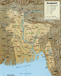
The Meghna (Bengali: মেঘনা নদী, romanized: Mēghanā Nadī) is one of the major rivers in Bangladesh,[2] one of the three that form the Ganges Delta, the largest delta on earth, which fans out to the Bay of Bengal. A part of the Surma-Meghna River System, the Meghna is formed inside Bangladesh in Kishoreganj District above the town of Bhairab Bazar by the joining of the Surma and the Kushiyara, both of which originate in the hilly regions of eastern India as the Barak River. The Meghna meets its major tributary, the Padma, in Chandpur District. Other major tributaries of the Meghna include the Dhaleshwari, the Gumti, and the Feni. The Meghna empties into the Bay of Bengal in Bhola District via four principal mouths, named Tetulia (Ilsha), Shahbazpur, Hatia, and Bamni.

The Meghna is the widest river that flows completely inside the boundaries of Bangladesh. At a point near Bhola, Meghna is 13 km wide. In its lower reaches, this river's path is almost perfectly straight.
- ^ a b c "Ganga (Ganges)-Brahmaputra".
- ^ Masud Hasan Chowdhury (2012). "Meghna River". In Sirajul Islam and Ahmed A. Jamal (ed.). Banglapedia: National Encyclopedia of Bangladesh (Second ed.). Asiatic Society of Bangladesh. Retrieved 27 February 2020.