Mehsana District | |
|---|---|
Clockwise from top-left: Modhera Sun Temple, Kirti Toran, Vadnagar, Umiya Mandir in Unjha, Mehsana city, Shitala Mata Temple, Buttapaldi | |
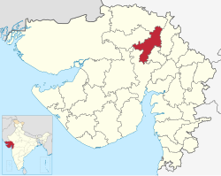
 Location of district in Gujarat | |
| Coordinates: 23°40′N 72°30′E / 23.667°N 72.500°E | |
| Country | |
| State | Gujarat |
| Headquarters | Mehsana |
| Area | |
• Total | 4,401 km2 (1,699 sq mi) |
| Population (2011) | |
• Total | 2,035,064 |
| • Density | 460/km2 (1,200/sq mi) |
| Languages | |
| • Official | Gujarati, Hindi, English |
| Time zone | UTC+5:30 (IST) |
| Vehicle registration | GJ-02 |
| Website | mehsanadp |
Mehsana district (alternate spelling "Mahesana") is one of the 33 districts of Gujarat state in western India.[1] Mehsana city is the administrative headquarters of this district. The district has a population of over 1.8 million and an area of over 4,500 km2. There are over 600 villages in this district with a population of 2,035,064 of which 22.40% were urban as of 2011.[2]
Mehsana district borders with Banaskantha district in the north, Patan and Surendranagar districts in west, Gandhinagar and Ahmedabad districts in south and Sabarkantha district in the east.
Major towns of the district are Mehsana, Vijapur, Bahucharaji, Satlasana, Modhera, Unjha, Vadnagar, Kalol, Kadi, Visnagar, Kherva, Jotana and Kheralu.
- ^ Official website
- ^ "Census GIS India". Archived from the original on 11 January 2010. Retrieved 20 November 2010.


