This article needs additional citations for verification. (April 2008) |
| Merbein Victoria | |||||||||||||||
|---|---|---|---|---|---|---|---|---|---|---|---|---|---|---|---|
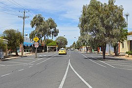
 Commercial Street, the main street of Merbein | |||||||||||||||
| Coordinates | 34°10′S 142°03′E / 34.167°S 142.050°E | ||||||||||||||
| Population | 4,976 (2021 census)[1] | ||||||||||||||
| Established | 1912 | ||||||||||||||
| Postcode(s) | 3505 | ||||||||||||||
| Elevation | 56 m (184 ft) | ||||||||||||||
| Location | |||||||||||||||
| LGA(s) | Rural City of Mildura | ||||||||||||||
| State electorate(s) | Mildura | ||||||||||||||
| Federal division(s) | Mallee | ||||||||||||||
| |||||||||||||||
| |||||||||||||||
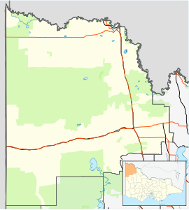
Merbein is a town just north of Mildura, Victoria, in the Sunraysia region of Australia. It is on the Calder Highway between Mildura and the Murray River crossing at the Abbotsford Bridge to Curlwaa. At the 2016 census, the town had a population of 1,981.[1] Merbein is 12 kilometres from Mildura, 553 kilometres (344 mi) from Melbourne and 389 kilometres (242 mi) from Adelaide.

The town is known for farming and is part what is informally called the "fruit bowl" or "food bowl", the growing region roughly made of the Coomealla and Sunraysia irrigation districts fed by the Darling and Murray rivers. Produce farmed in Merbein include grapes, citrus, mushrooms, green beans, asparagus and pistachios.

Merbein is also home of Mildara Wines, a winery W B Chaffey had built in 1913 for the first intake of grapes in 1914. The winery, originally known as the Mildura Distillery and Winery, stands on a 30-metre sandstone cliff near Pump Hill.
- ^ a b "Merbein – 2021 Census All persons QuickStats". Australian Bureau of Statistics. Retrieved 23 September 2022.
