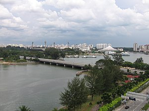
Merdeka Bridge, Singapore | |
|---|---|
 Merdeka Bridge | |
| Coordinates | 1°18′15″N 103°52′6″E / 1.30417°N 103.86833°E |
| Carries | 6 lanes of Nicoll Highway, pedestrians and bicycles |
| Crosses | Kallang Basin |
| Locale | Kallang, Singapore |
| Official name | Merdeka Bridge |
| Other name(s) | 独立桥 (Chinese) Jambatan Merdeka (Malay) |
| Maintained by | CPG Corporation |
| Characteristics | |
| Design | Beam, Pre-stressed bridge |
| Material | Concrete |
| Total length | 2,000 ft (609.6 m), about 0.378 mi (0.6 km) |
| Width | 65 ft (19.8 m) |
| Longest span | 80 ft (24.4 m) |
| History | |
| Designer | R. J. Hollis-Bee |
| Constructed by | Paul Y. Construction Company and Hume Industries |
| Construction start | January 1955 |
| Construction end | August 1956 |
| Opened | 17 August 1956 |
| Location | |
 | |
The Merdeka Bridge (Chinese: 独立桥, Malay: Jambatan Merdeka) is a vehicular and pedestrian bridge located in Kallang in the south-eastern part of Singapore. It spans the river mouths of the Kallang River and Rochor River, which empty into the Kallang Basin. Designed by R. J. Hollis-Bee of the then Public Works Department (now CPG Corporation), the bridge was officially opened on 17 August 1956.
The Merdeka Bridge carries Nicoll Highway, a semi-expressway connecting Kallang with the Singapore downtown.