| Merewether Newcastle, New South Wales | |||||||||||||||
|---|---|---|---|---|---|---|---|---|---|---|---|---|---|---|---|
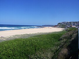
 Merewether Beach | |||||||||||||||
| Coordinates | 32°56′34″S 151°45′9″E / 32.94278°S 151.75250°E | ||||||||||||||
| Population | 10,964 (2016 census)[1] | ||||||||||||||
| • Density | 3,049.4/km2 (7,898/sq mi) Note1 | ||||||||||||||
| Established | 1890 | ||||||||||||||
| Postcode(s) | 2291 | ||||||||||||||
| Area | 6.1 km2 (2.4 sq mi) | ||||||||||||||
| Location |
| ||||||||||||||
| LGA(s) | City of Newcastle | ||||||||||||||
| Region | Hunter | ||||||||||||||
| County | Northumberland | ||||||||||||||
| Parish | Newcastle | ||||||||||||||
| State electorate(s) | Newcastle | ||||||||||||||
| Federal division(s) | Newcastle | ||||||||||||||
| |||||||||||||||
Merewether (/ˈmɛrɪˌwɛðər/) is a former Municipality and today a suburb of Newcastle, New South Wales, Australia, located 3 km (2 mi) from Newcastle's central business district with a population of around 11,000.[2] The suburb stretches 3 km (2 mi) from Merewether Beach in the east to Adamstown in the west.
- ^ Australian Bureau of Statistics (27 June 2017). "Merewether (State Suburb)". 2016 Census QuickStats. Retrieved 9 February 2018.
- ^ "2016 Merewether, Census All persons QuickStats | Australian Bureau of Statistics".
