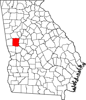
Meriwether County | |
|---|---|
 Meriwether County Courthouse in Greenville | |
 Location within the U.S. state of Georgia | |
 Georgia's location within the U.S. | |
| Coordinates: 33°02′N 84°41′W / 33.04°N 84.69°W | |
| Country | |
| State | |
| Founded | 1827 |
| Named for | David Meriwether |
| Seat | Greenville |
| Largest city | Manchester |
| Area | |
• Total | 505 sq mi (1,310 km2) |
| • Land | 501 sq mi (1,300 km2) |
| • Water | 4.2 sq mi (11 km2) 0.8% |
| Population (2020) | |
• Total | 20,613[1] |
| Time zone | UTC−5 (Eastern) |
| • Summer (DST) | UTC−4 (EDT) |
| Congressional district | 3rd |
| Website | meriwethercountyga.gov |
Meriwether County is a county in the West Central region of the U.S. state of Georgia. As of the 2020 census, the population was 20,613.[2][1] The county seat is Greenville,[3] home of the Meriwether County Courthouse. The county was formed on December 14, 1827, as the 73rd county in Georgia. It was named for David Meriwether, a general in the American Revolutionary War and member of Congress from Georgia.[4]
Meriwether County is part of the Atlanta-Sandy Springs-Roswell MSA.
- ^ a b US 2020 Census Bureau report, Meriwether County, Georgia
- ^ "State & County QuickFacts". United States Census Bureau. Archived from the original on June 7, 2011. Retrieved June 24, 2014.
- ^ "Find a County". National Association of Counties. Retrieved June 7, 2011.
- ^ Gannett, Henry (1905). The Origin of Certain Place Names in the United States. U.S. Government Printing Office. p. 206.

