| Merowe Dam | |
|---|---|
 | |
| Location | Merowe, Sudan |
| Coordinates | 18°40′08″N 32°03′01″E / 18.66889°N 32.05028°E |
| Status | Operational |
| Construction began | 2004 |
| Opening date | March 3, 2009 |
| Construction cost | €1.2 billion |
| Dam and spillways | |
| Impounds | River Nile |
| Height | 67 m (220 ft) |
| Length | 9 km (5.6 mi) |
| Reservoir | |
| Creates | Merowe Reservoir |
| Total capacity | 12.5 km3 (10,100,000 acre⋅ft) |
| Surface area | 476 km2 |
| Power Station | |
| Turbines | 10 × 125 MW (168,000 hp) Francis-type[1] |
| Installed capacity | 1,250 MW (1,680,000 hp) |
| Annual generation | 5.5 TWh (20 PJ) |
| Website http://www.merowedam.gov.sd/ | |
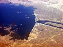
The Merowe Dam, also known as Merowe High Dam, Merowe Multi-Purpose Hydro Project or Hamdab Dam, is a large dam near Merowe Town in northern Sudan, about 350 kilometres (220 mi) north of the capital Khartoum. Its dimensions make it the largest contemporary hydropower project in Africa. It is situated on the river Nile, close to and inundating the 4th Cataract where the river divides into multiple smaller branches with large islands in between. Merowe is a city about 40 kilometres (25 mi) downstream from the construction site at Hamdab. The main purpose for building the dam was the generation of electricity.[2]
- ^ "Power Plant". Merowe Dam Implementation Unit. Retrieved 22 June 2011.
- ^ Merowe Dam, Nile River, Republic of Sudan, NASA Earth Observatory
