Merthyr Tydfil County Borough
Bwrdeistref Sirol Merthyr Tudful (Welsh) | |
|---|---|
| |
| Motto(s): | |
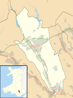
 Merthyr Tydfil shown within Wales | |
| Coordinates: 51°45′N 3°23′W / 51.750°N 3.383°W | |
| Sovereign state | United Kingdom |
| Country | Wales |
| Preserved county | Mid Glamorgan |
| Incorporated | 1 April 1974 |
| Unitary authority | 1 April 1996 |
| Named for | Merthyr Tydfil |
| Administrative HQ | Civic Centre, Merthyr Tydfil |
| Government | |
| • Type | Principal council |
| • Body | Merthyr Tydfil County Borough Council |
| • Control | Independent |
| • MPs | Gerald Jones (L) |
| • MSs | |
| Area | |
| • Total | 43 sq mi (111 km2) |
| • Rank | 21st |
| Population (2022)[2] | |
| • Total | 58,883 |
| • Rank | 22nd |
| • Density | 1,370/sq mi (528/km2) |
| Welsh language (2021) | |
| • Speakers | 8.9% |
| • Rank | 15th |
| Time zone | UTC+0 (GMT) |
| • Summer (DST) | UTC+1 (BST) |
| ISO 3166 code | GB-MTY |
| GSS code | W06000024 |
| Website | merthyr |
Merthyr Tydfil County Borough (Welsh: Bwrdeistref Sirol Merthyr Tudful) is a county borough (since 1908) in the south-east of Wales. In 2022, it had an estimated population of 58,883,[2] making it the smallest local authority in Wales by population. It is located in the historic county of Glamorgan and takes its name from the town with the same name. The county borough consists of the northern part of the Taff Valley and the smaller neighbouring Taff Bargoed Valley. It borders the counties of Rhondda Cynon Taf to the west, Caerphilly County Borough to the east, and Powys to the north.
- ^ "Council". Merthyr Tydfil County Borough Council. Retrieved 6 August 2024.
- ^ a b c "Mid-Year Population Estimates, UK, June 2022". Office for National Statistics. 26 March 2024. Retrieved 3 May 2024.
- ^ "How life has changed in Merthyr Tydfil: Census 2021". Office for National Statistics. 19 January 2023. Retrieved 6 August 2024.


