Mesa, Arizona | |
|---|---|
 Mesa Arts Center building in downtown Mesa | |
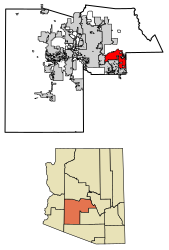
 Location of Mesa in Maricopa County, Arizona | |
| Coordinates: 33°25′20″N 111°49′22″W / 33.42222°N 111.82278°W[1] | |
| Country | United States |
| State | Arizona |
| County | Maricopa |
| Founded | 1878 |
| Government | |
| • Type | Mayor–council |
| • Mayor | John Giles (R) |
| Area | |
| • Total | 139.42 sq mi (361.09 km2) |
| • Land | 138.79 sq mi (359.48 km2) |
| • Water | 0.62 sq mi (1.62 km2) |
| Elevation | 1,326 ft (404 m) |
| Population (2020) | |
| • Total | 504,258 |
| • Estimate (2021)[3] | 509,475 |
| • Rank | 36th in the United States 3rd in Arizona |
| • Density | 3,633.14/sq mi (1,402.76/km2) |
| Time zone | UTC−7 (MST (no DST)) |
| ZIP codes | 85201-85216, 85274-85275, 85277 |
| Area code | 480 602 |
| FIPS code | 04-46000 |
| GNIS feature ID | 2411087[1] |
| Website | www |
Mesa (/ˈmeɪsə/ MAY-sə) is a city in Maricopa County, Arizona, United States. It is the third-most populous city in Arizona, after Phoenix and Tucson, the 36th-most populous city in the U.S., and the most populous city that is not a county seat (except for independent cities Washington, D.C. and Baltimore which are not part of any county). The city is home to 504,258 people as of 2020.[4] It is the most populous city in the East Valley of the Phoenix metropolitan area.[5] It is bordered by Tempe on the west, the Salt River Pima–Maricopa Indian Community on the north, Chandler and Gilbert on the south along with Queen Creek, and Apache Junction on the east.
At least ten colleges and universities are located in Mesa, as is the Mesa Arizona Temple, one of the first LDS temples constructed outside of Utah. The city is home to the largest relief airport in the Phoenix area, Phoenix–Mesa Gateway Airport, located in the southeastern corner of the city. In separate studies in 2014 and 2017, researchers determined Mesa to be "America's most conservative city".[6][7]
- ^ a b c U.S. Geological Survey Geographic Names Information System: Mesa, Arizona
- ^ "2020 U.S. Gazetteer Files". United States Census Bureau. Retrieved October 29, 2021.
- ^ "City and Town Population Totals: 2020-2021". United States Census Bureau. May 29, 2022. Retrieved May 31, 2022.
- ^ "QuickFacts: Mesa city, Arizona". United States Census Bureau. Retrieved August 26, 2021.
- ^ "How to Tell If You Live in the Suburbs". Bloomberg News. July 7, 2020.
- ^ Epstein, Ethan (September 17, 2014). "Are Conservative Cities Better?". Politico Magazine. Retrieved September 25, 2021.
- ^ "Mesa ranked most conservative large city in the U.S. by Pew". East Valley Tribune. July 24, 2017. Retrieved November 21, 2023.


