Mesa County | |
|---|---|
 Old Mesa County Courthouse in Grand Junction | |
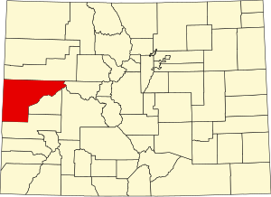
 Location within the U.S. state of Colorado | |
 Colorado's location within the U.S. | |
| Coordinates: 39°01′N 108°28′W / 39.02°N 108.47°W | |
| Country | |
| State | |
| Founded | February 14, 1883 |
| Named for | Mesas in the area |
| Seat | Grand Junction |
| Largest city | Grand Junction |
| Area | |
| • Total | 3,341 sq mi (8,650 km2) |
| • Land | 3,329 sq mi (8,620 km2) |
| • Water | 12 sq mi (30 km2) 0.4% |
| Population (2020) | |
| • Total | 155,703 |
| • Estimate (2023)[1] | 159,681 |
| • Density | 47/sq mi (18/km2) |
| Time zone | UTC−7 (Mountain) |
| • Summer (DST) | UTC−6 (MDT) |
| Congressional district | 3rd |
| Website | www |

Mesa County is a county located in the U.S. state of Colorado. As of the 2020 census, the population was 155,703.[2] The county seat and most populous municipality is Grand Junction.[3] The county was named for the many large mesas in the area, including the Grand Mesa, which is the largest flat-topped mountain in the world.
Mesa County comprises the Grand Junction, CO Metropolitan Statistical Area.[4][5] In 2020 it ranked as the 271st most populous metropolitan area in the United States.[2] It is the only metropolitan area in Colorado not located on the Front Range.
- ^ "Annual Estimates of the Resident Population for Counties: April 1, 2020 to July 1, 2023". United States Census Bureau. Retrieved March 24, 2024.
- ^ a b "State & County QuickFacts". United States Census Bureau. Retrieved September 5, 2021.
- ^ "Find a County". National Association of Counties. Retrieved June 7, 2011.
- ^ "OMB Bulletin No. 10-02: Update of Statistical Area Definitions and Guidance on Their Uses" (PDF). Office of Management and Budget. December 1, 2009. Archived (PDF) from the original on January 21, 2017. Retrieved April 19, 2012 – via National Archives.
- ^ See the Colorado census statistical areas.