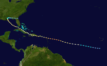
 Track of Hurricane Georges | |
| Meteorological history | |
|---|---|
| Formed | September 15, 1998 |
| Dissipated | October 1, 1998 |
| Category 4 major hurricane | |
| 1-minute sustained (SSHWS/NWS) | |
| Highest winds | 155 mph (250 km/h) |
| Lowest pressure | 937 mbar (hPa); 27.67 inHg |
| Overall effects | |
| Areas affected | Leeward Islands, Puerto Rico, Dominican Republic, Haiti, Cuba, Florida Keys, Mississippi, Alabama, Southeastern Louisiana, Florida Panhandle |
Part of the 1998 Atlantic hurricane season | |
| History
Effects
Other wikis | |
The meteorological history of Hurricane Georges spanned seventeen days from September 15 to October 1, 1998. Hurricane Georges began as a tropical wave that moved off the coast of Africa during mid-September 1998. Tracking westward, the wave spawned an area of low pressure two days later, which quickly strengthened into a tropical depression. On September 16, the depression was upgraded to Tropical Storm Georges, and to Hurricane Georges the next day. Over the next few days, an eye developed and deep Atmospheric convection persisted around it. Strong outflow and warm sea surface temperatures allowed the storm to intensify as it tracked towards the west-northwest. The storm reached its peak intensity on September 20 with winds of 155 mph (250 km/h), just below Category 5 status on the Saffir–Simpson hurricane scale, and a barometric pressure of 937 mbar (hPa; 27.67 inHg).[1]
Over the following five days, the hurricane tracked through the Greater Antilles, making five landfalls, four as a Category 3 hurricane and one as a Category 1. Shortly after entering the Caribbean, the Georges weakened slightly; however, shortly before crossing Puerto Rico, the storm re-attained major hurricane status. After weakening slightly once more, the storm rapidly organized near the Dominican Republic. A well-defined eye formed and outflow re-established, allowing the storm to reach an intensity of 120 mph (195 km/h) just prior to landfall. During its passage of Hispaniola the circulation was severely disrupted, but Georges maintained hurricane-intensity. On September 23, the storm made landfall in southeastern Cuba as a minimal hurricane.[1]
By September 25, Georges entered the Gulf of Mexico and intensified into a Category 2 hurricane. The storm re-organized over the gulf, with the eye fully reforming and deep convection persisting around the center of circulation. By September 27, Georges reached an intensity of 110 mph (175 km/h). Several hours prior to landfall the next day, the hurricane weakened slightly and tracked inland near Biloxi, Mississippi with winds of 105 mph (170 km/h). Upon landfall, the hurricane's forward motion slowed, executing a brief clockwise loop before maintaining an eastward drift. Gradually weakening, the hurricane was only a tropical depression by the afternoon of September 29. Two days later, Georges fully dissipated near the Atlantic coast of Florida.[1]