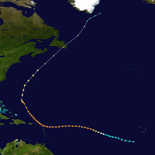
 Track map of Hurricane Luis | |
| Meteorological history | |
|---|---|
| Formed | August 27, 1995 |
| Extratropical | September 11 |
| Dissipated | September 12, 1995 |
| Category 4 major hurricane | |
| 1-minute sustained (SSHWS/NWS) | |
| Highest winds | 150 mph (240 km/h) |
| Lowest pressure | 935 mbar (hPa); 27.61 inHg |
| Overall effects | |
| Areas affected | Leeward Islands (especially Antigua and Barbuda, St. Kitts and Nevis, Sint Eustatius, Saba, Saint Barthélemy, St. Martin and Anguilla), Puerto Rico, Bermuda, parts of the Northeastern USA, Newfoundland |
Part of the 1995 Atlantic hurricane season | |
The meteorological history of Hurricane Luis spanned sixteen days between August 27 to September 11, 1995. The storm originated from an area of low pressure associated with a tropical wave on August 26. The following day, the low became sufficiently organized to be classified as a tropical depression, while tracking general westward. By August 29, the depression intensified into a tropical storm and was given the name Luis by the National Hurricane Center. Luis attained hurricane status the following day as an eye began to develop. On September 1 the cyclone intensified into a major hurricane—a storm with winds of 111 mph (179 km/h) or higher—and further strengthened to a Category 4 hurricane later that day.
Hurricane Luis maintained wind speeds of 130 mph (210 km/h) for nearly two days and developed a symmetrical structure with a well-defined 46 mi (74 km) wide eye. Early on September 3, winds within the eyewall reached 150 mph (240 km/h). Luis weakened slightly maintained this intensity until September 5, shortly before passing through the Leeward Islands with 130 mph (210 km/h) winds. The hurricane maintained Category 4 status until September 7 as it tracked towards the northwest. Gradual weakening took place for several days and by September 9, the hurricane passed about 200 mi (320 km) west of Bermuda. The next day, Luis began to undergo an extratropical transition and the storm's forward motion rapidly increased. Early on September 11, Luis made landfall on the Avalon Peninsula as a strong Category 1 hurricane with winds of 90 mph (145 km/h). The same day, a 30 metres (98 ft) wave produced by Luis struck an ocean liner. This wave is the largest ever recorded,[1] Several hours later, the storm completed its extratropical transition as it began to be absorbed into an approaching trough. The following day, the remnants of Luis were fully absorbed into the trough near the southern coast of Greenland.