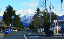
Methven | |
|---|---|
 Methven town centre | |
 | |
| Coordinates: 43°38′S 171°39′E / 43.633°S 171.650°E | |
| Country | New Zealand |
| Region | Canterbury |
| Territorial authority | Ashburton District |
| Community board | Methven Community Board[1] |
| Ward | Western |
| Electorates |
|
| Government | |
| • Territorial authority | Ashburton District Council |
| • Regional council | Environment Canterbury |
| • Mayor of Ashburton | Neil Brown |
| • Rangitata MP | James Meager |
| • Te Tai Tonga MP | Tākuta Ferris |
| Area | |
| • Total | 4.77 km2 (1.84 sq mi) |
| Elevation | 320 m (1,050 ft) |
| Population (June 2024)[3] | |
| • Total | 2,080 |
| • Density | 440/km2 (1,100/sq mi) |
| Postcode | 7730 |
| Area code | 03 |
Methven is a small town in the Canterbury region of the South Island of New Zealand. It is located near the western edge of the Canterbury Plains, 35 km (22 mi) north of Ashburton and 95 km (59 mi) west of Christchurch, and at an elevation of 320 m (1,050 ft).[4] The town is a service centre for agriculture in the surrounding area, and is a base for skiing at the nearby Mount Hutt skifield. The town slogan is "Amazing Space".[5]
- ^ "Methven Community Board". www.ashburtondc.govt.nz. Ashburton District Council. Retrieved 11 July 2022.
- ^ Cite error: The named reference
Areawas invoked but never defined (see the help page). - ^ "Aotearoa Data Explorer". Statistics New Zealand. Retrieved 26 October 2024.
- ^ "Topgraphic maps – Methven". Archived from the original on 8 September 2021. Retrieved 8 September 2021.
- ^ Easther, Elizabeth (13 February 2015). "Best things to see and do in Methven". NZ Herald. Retrieved 12 October 2020.