Mexicali Municipality
Municipio de Mexicali | |
|---|---|
| Motto(s): Tierra Cálida (Warm Land) | |
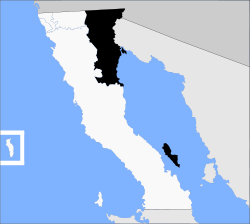
 Location of Mexicali in Baja California. | |
| Country | Mexico |
| State | Baja California |
| Municipal seat | Mexicali |
| Largest city | Mexicali |
| Municipality established | 29 December 1953[1] |
| Government | |
| • Municipal president | Norma Alicia Bustamante Martínez (MORENA) |
| Area | |
| • Total | 13,700 km2 (5,300 sq mi) |
| Population (2020) | |
| • Total | 1,049,792 |
| • Density | 77/km2 (200/sq mi) |
| Data source:[2] | |
| Time zone | UTC−8 (Northwest (US Pacific)) |
| • Summer (DST) | UTC−7 (Northwest) |
| INEGI code | 002 |
| Website | (in Spanish) Ayuntamiento de Mexicali |
| Source: Enciclopedia de los Municipios de México | |
Mexicali Municipality is a municipality (Spanish: municipio) in the Mexican state of Baja California. Its municipal seat (Spanish: cabecera municipal) is located in the city of Mexicali. As of 2020, the municipality had a total population of 1,049,792.[2] The municipality has an area of 13,700 km2 (5,300 sq mi). This includes many smaller outlying communities as well as the city of Mexicali. Also, the islands of Baja California located in the Gulf of California are part of the municipality, among them the mudflat islands at the mouth of the Colorado River (the largest one being Montague Island), Isla Ángel de la Guarda and the islands of the San Lorenzo Marine Archipelago National Park. Mexicali is the northernmost municipality of Latin America.
The city of Mexicali was founded in 1903, and its name is a portmanteau of Mexico and California, as is the name of Calexico, California across the border.
- ^ (in Spanish) pp. 78–79, La Transformación de Baja California en Estado, 1931–1952 Archived 29 September 2011 at the Wayback Machine, Lawrence Douglas Taylor Hansen, Estudios Fronterizos, 1, No. 1 (January–June 2000), UABC, Mexicali, pp. 47–87.
- ^ a b "México en cifras". January 2016.

