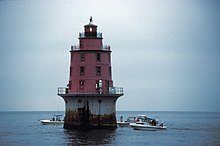
 | |
 | |
| Location | Lower Delaware Bay 5 mi. SW of Egg Island Point, Delaware Bay |
|---|---|
| Coordinates | 39°7′36″N 75°12′35″W / 39.12667°N 75.20972°W |
| Tower | |
| Constructed | 1913 |
| Foundation | cast iron caisson |
| Construction | cast iron |
| Automated | 1974 |
| Height | 14 m (46 ft) |
| Shape | conical with lantern on top |
| Heritage | National Register of Historic Places listed place |
| Racon | M |
| Light | |
| Focal height | 59 feet (18 m) |
| Lens | fourth order Fresnel lens (original), 500 millimetres (20 in) (current) |
| Range | 12 nautical miles (22 km; 14 mi) |
| Characteristic | Occulting 4s |
Miah Maull Shoal Lighthouse | |
| Area | 0.7 acres (0.28 ha) |
| Architect | Lynchburg Foundry Co.; Tatnall-Brown Co. |
| Architectural style | Conical tower lighthouse |
| NRHP reference No. | 90002188[1] |
| NJRHP No. | [2] |
| Added to NRHP | February 4, 1991 |
The Miah Maull Shoal Light is a lighthouse on the north side of the ship channel in Delaware Bay, off of Cumberland County, New Jersey on the East Coast of the United States, southwest of the mouth of the Maurice River.
- ^ "National Register Information System". National Register of Historic Places. National Park Service. March 13, 2009.
- ^ "New Jersey and National Registers of Historic Places - Cumberland County" (PDF). NJ DEP - Historic Preservation Office. April 1, 2010. p. 12. Archived from the original (PDF) on July 9, 2003. Retrieved October 13, 2010.