| Middle Fork Clearwater River | |
|---|---|
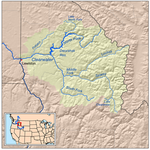
 Map of the Clearwater River watershed, including the Middle Fork | |
| Location | |
| Country | United States |
| State | Idaho |
| Physical characteristics | |
| Source | Confluence of Lochsa River and Selway River |
| • location | Lowell, Idaho |
| • coordinates | 46°08′25″N 115°35′58″W / 46.14028°N 115.59944°W[1] |
| Mouth | Clearwater River |
• location | Kooskia, Idaho |
• coordinates | 46°08′44″N 115°58′57″W / 46.14556°N 115.98250°W[1] |
• elevation | 1,224 ft (373 m) |
| Length | 23 mi (37 km)[2] |
| Basin size | 3,420 sq mi (8,900 km2)[3] |
| Discharge | |
| • location | Lowell[n 1] |
| • average | 6,532 cu ft/s (185.0 m3/s)[n 2] |
| • minimum | 260 cu ft/s (7.4 m3/s) |
| • maximum | 77,200 cu ft/s (2,190 m3/s) |
| Basin features | |
| Tributaries | |
| • left | Selway River, Clear Creek |
| • right | Lochsa River, Pete King Creek, Maggie Creek |
| Type | Recreational |
| Designated | October 2, 1968 |
The Middle Fork Clearwater River is a short, but high volume river in Idaho County, Idaho, United States and is the major source of the Clearwater River, a tributary of the Snake River.
- ^ a b "Middle Fork Clearwater River". Geographic Names Information System. United States Geological Survey, United States Department of the Interior. Retrieved 2016-06-01.
- ^ USGS Topo Maps for United States (Map). Cartography by United States Geological Survey. ACME Mapper. Retrieved 2016-06-01.
- ^ "Boundary Descriptions and Names of Regions, Subregions, Accounting Units and Cataloging Units". United States Geological Survey. Retrieved 2016-06-01.
- ^ "USGS Gage #13336500 on the Selway River near Lowell, Idaho" (PDF). National Water Information System. U.S. Geological Survey. Retrieved 2016-06-01.
- ^ "USGS Gage #13337000 on the Lochsa River near Lowell, ID" (PDF). National Water Information System. U.S. Geological Survey. Retrieved 2016-06-01.
Cite error: There are <ref group=n> tags on this page, but the references will not show without a {{reflist|group=n}} template (see the help page).