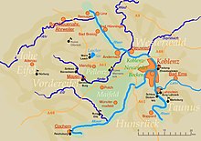
The Middle Rhine Basin (German: Mittelrheinische Becken) is the central landscape region of the Middle Rhine in Germany and, along with the Limburg Basin, forms one of the biggest intra-montane lowland regions within the Rhenish Massif. The basin is divided into the valley bottom of the Neuwied Basin, the Neuwied Basin Perimeter east of the Rhine and the Lower Moselle Valley west of the Rhine in the south, and the Maifeld-Pellenz Hills in the north.
The basin is bounded on the east of the Rhine in the northeast and east by the slopes of the Westerwald and, on the west of the Rhine, from north to southwest by the Eifel mountains, and in the southeast by the valley of the Moselle above Moselkern. Its mild winters and dry climate enable intensive agriculture, which is why the landscape has few woods.