This article contains a bulleted list or table of intersections which should be presented in a properly formatted junction table. (December 2021) |
Midland Highway | |
|---|---|
 | |
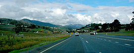
| Midland Highway, at Dysart | |
 | |
| General information | |
| Type | Highway |
| Length | 176 km (109 mi) |
| Route number(s) | Hobart – Launceston |
| Former route number | |
| Major junctions | |
| South end | Granton, Hobart, Tasmania |
| |
| North end | Launceston, Tasmania |
| Location(s) | |
| Region | Tasmania |
| Major settlements | Perth, Epping Forest, Campbell Town, Ross, Oatlands, Bagdad, Brighton, Bridgewater |
| Highway system | |
| ---- | |

The Midland Highway (also known as the Midlands Highway) is one of Tasmania's major inter-city highways, running for 176 kilometres (109 mi) between Hobart and Launceston. It is part of the AusLink National Network and is a vital link for road freight to transport goods to and from the two cities. It represents a major north–south transportation corridor in Tasmania and has the route 1 designation as part of the National Highway. The highway consists of various traffic lane arrangements, the most common being two lanes – one in each direction, with overtaking options and at-grade intersections. At both the Launceston and Hobart sections of the highway there are small portions of grade-separated dual carriageway.
- ^ Former State Route Numbering System in Tasmania, Ozroads: the Australian Roads Website. Retrieved 30 January 2008.