Mieszkowice | |
|---|---|
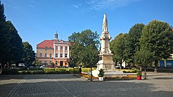
 Plac Wolności (Freedom Square) with the monument of Mieszko I in the foreground and town hall in the background | |
| Coordinates: 52°47′N 14°29′E / 52.783°N 14.483°E | |
| Country | |
| Voivodeship | West Pomeranian |
| County | Gryfino |
| Gmina | Mieszkowice |
| First mentioned | 1285 |
| Town rights | 1298 |
| Area | |
| • Total | 4.73 km2 (1.83 sq mi) |
| Population (2006) | |
| • Total | 3,553 |
| • Density | 750/km2 (1,900/sq mi) |
| Time zone | UTC+1 (CET) |
| • Summer (DST) | UTC+2 (CEST) |
| Postal code | 74-505 |
| Vehicle registration | ZGR |
| National roads | |
| Voivodeship roads | |
| Website | http://www.mieszkowice.pl |
Mieszkowice [mʲɛʂkɔˈvʲit͡sɛ] (German: Bärwalde in der Neumark; Kashubian: Berwôłd) is a town in Gryfino County, West Pomeranian Voivodeship in western Poland, about 15 km (9.3 mi) east of the Oder river and the border with Germany. It is the administrative seat of the urban-rural gmina (municipality) of Mieszkowice.
With origins as a medieval settlement within the borders of the Kingdom of Poland, it was founded as a town in the late 13th century during the Ostsiedlung, after the annexation of the area by Brandenburg, the town was the site of death of the last Ascanian margrave in 1319, a center of the Waldensians movement in the 14th century, and the site of the conclusion of a Franco-Swedish alliance during the Thirty Years' War, which else virtually depopulated the town. After the war, the town slowly recovered, retaining a rural character. In the late 19th century, it was connected to the railroad. During World War II the town largely escaped destruction, and in 1945 became again part of Poland. It was renamed Barwice, then Mieszkowice after Mieszko I of Poland, the first historic ruler of Poland, who first included the area within the emerging Polish state.


