| Milefortlet 5 | |
|---|---|
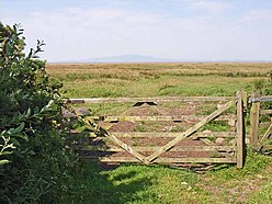
 View over the Solway marshes, north of the site of Milefortlet 5 | |
| Type | Milecastle |
| Place in the Roman world | |
| Province | Britannia |
| Location | |
| Coordinates | 54°54′48″N 3°17′44″W / 54.913343°N 3.29555°W |
| County | Cumbria |
| Country | England |
| Reference | |
| UK-OSNG reference | NY17045839 |
Milefortlet 5 (Cardurnock) was a Milefortlet of the Roman Cumbrian Coast defences. These milefortlets and intervening stone watchtowers extended from the western end of Hadrian's Wall, along the Cumbrian coast and were linked by a wooden palisade. They were contemporary with defensive structures on Hadrian's Wall. The remains of Milefortlet 5 was excavated in 1943-4 prior to its destruction in 1944.
