| Mill Bluff State Park | |
|---|---|
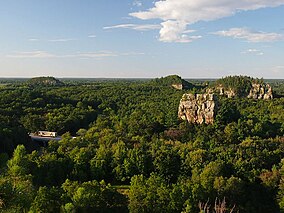
 The view north from Mill Bluff, with Wildcat Bluff on the left and the two humps of Camels Bluff on the right with Bee Bluff between them | |
| Location | Wisconsin, United States |
| Coordinates | 43°56′47″N 90°18′55″W / 43.94639°N 90.31528°W |
| Area | 1,337 acres (5.41 km2) |
| Elevation | 955 ft (291 m)[1] |
| Established | 1936 |
| Governing body | Wisconsin Department of Natural Resources |
Mill Bluff State Park is a state park in west-central Wisconsin, United States. It is located in eastern Monroe and western Juneau counties, near the village of Camp Douglas. A unit of the Ice Age National Scientific Reserve, the park protects several prominent sandstone bluffs 80 feet (24 m) to 200 feet (61 m) high that formed as sea stacks 12,000 years ago in Glacial Lake Wisconsin. As a result, these bluffs are steep and angular, dissimilar to the rounded terrain more typical of the eastern half of the United States. The bluffs served as landmarks to both early pioneers and travelers today on Interstate 90/94, which passes through the park.
- ^ "Mill Bluff State Park". Geographic Names Information System. United States Geological Survey. August 29, 1980. Retrieved March 18, 2011.

