Minaki | |
|---|---|
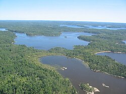
 A mosaic of lakes on the northern edge of Minaki | |
| Coordinates: 49°59′11″N 94°40′12″W / 49.98639°N 94.67000°W | |
| Country | Canada |
| Province | Ontario |
| Region | Northwestern Ontario |
| District | Kenora |
| Part | Kenora, Unorganized |
| Elevation | 321 m (1,053 ft) |
| Time zone | UTC-6 (Central Time Zone) |
| • Summer (DST) | UTC-5 (Central Time Zone) |
| Postal code FSA | P0X |
| Area code | 807 |
Minaki (/məˈnæˌkiː/ mih-NAH-kee or /miːnɑːˈkiː/ mee-nah-KEE)[dubious – discuss] is an unincorporated area and community in Unorganized Kenora District in northwestern Ontario, Canada.[1] It is located at the point where the Canadian National Railways transcontinental main line crosses the Winnipeg River,[2] between Wade to the west and Ena Lake at the east, and was accessible only by rail until about 1960. It was a fuelling and watering point in the days of steam locomotives; now few trains stop in Minaki, though the thrice-weekly Via Rail transcontinental Canadian passenger trains will stop on request at the Minaki railway station.
Tourism is the economic mainstay of Minaki, with camps, lodges and marinas catering to anglers and hunters. It is the embarkation point for more than 100 water-access cottages on surrounding lakes. The largest group of cottagers are from Winnipeg, about 3 hours drive away, and from nearby U.S. states.
- ^ "Minaki". Geographical Names Data Base. Natural Resources Canada. Retrieved 2011-08-15.
- ^ Map 13 (PDF) (Map). 1 : 1,600,000. Official road map of Ontario. Ministry of Transportation of Ontario. 2010-01-01. Retrieved 2011-08-15.
