Minamata
水俣市 | |
|---|---|
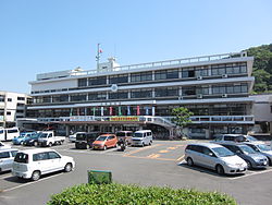
 Minamata City Hall | |
 Location of Minamata in Kumamoto Prefecture | |
| Coordinates: 32°13′N 130°24′E / 32.217°N 130.400°E | |
| Country | |
| Region | Kyūshū |
| Prefecture | |
| Government | |
| • Mayor | Toshiharu Takaoka |
| Area | |
• Total | 162.88 km2 (62.89 sq mi) |
| Population (October 1, 2020) | |
• Total | 23,580 |
| • Density | 144.4/km2 (374/sq mi) |
| Time zone | UTC+09:00 (JST) |
| Postal code | 867-8555 |
| Phone number | 0966-63-1111 |
| Address | 1-1-1 Jinnai, Minamata-shi, Kumamoto-ken |
| Climate | Cfa |
| Website | Official website |
| Symbols | |
| Flower | Rhododendron |
| Tree | Sakura |
Minamata (水俣市, Minamata-shi) is a city located in Kumamoto Prefecture, Japan. It is on the west coast of Kyūshū and faces Amakusa islands. Minamata was established as a village in 1889, re-designated as a town in 1912 and grew into a city in 1949.[1] As of March 2017, the city has an estimated population of 25,310[2] and a population density of 160 persons per km2. The total area is 162.88 km2.
Minamata is known due to Minamata disease, a neurological disorder caused by mercury poisoning. The disease was discovered in 1956.[1] A local chemical plant was blamed for causing the disease by emitting untreated wastewater into Minamata Bay.
Lately, Minamata has focused on becoming a model environmental city. In 1999, the city obtained the ISO 14001 certification for Environmental Management.[1] In 2001, Minamata became an official Japanese Eco-town.[3] In 2004 and 2005, Minamata won the Japanese Top Eco-City contest.[4]
- ^ a b c "History of Minamata". Archived from the original on 4 March 2016. Retrieved 11 October 2012.
- ^ "Official website of Minamata City" (in Japanese). Japan: Minamata City. Retrieved 29 April 2017.
- ^ Eco-Towns in Japan - Implications and Lessons for Developing Countries and Cities (PDF). Global Environment Centre Foundation. 2005. Archived from the original (PDF) on 2016-03-04. Retrieved 2012-10-11.
- ^ "[Ecomap] Minatama City: City-wide Efforts to be a Model Environmental City, Getting Over Minamata Disease". Japan for Sustainability. Archived from the original on 3 October 2013. Retrieved 11 October 2012.


