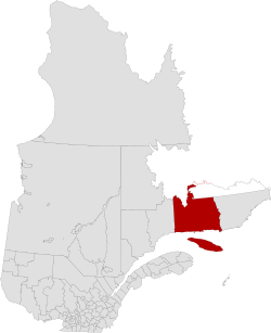
Minganie | |
|---|---|
 | |
| Coordinates: 50°14′N 63°36′W / 50.233°N 63.600°W | |
| Country | Canada |
| Province | Quebec |
| Region | Côte-Nord |
| Effective | January 1, 1982 |
| County seat | Havre-Saint-Pierre |
| Government | |
| • Type | Prefecture |
| • Prefect | Meggie Richard |
| Area | |
| • Total | 63,731.31 km2 (24,606.80 sq mi) |
| • Land | 53,340.31 km2 (20,594.81 sq mi) |
| Includes native reserves | |
| Population (2021)[3] | |
| • Total | 6,467 |
| • Density | 0.1/km2 (0.3/sq mi) |
| • Pop (2016-21) | |
| • Dwellings | 3,306 |
| Includes native reserves | |
| Time zone | UTC−5 (EST) |
| • Summer (DST) | UTC−4 (EDT) |
| Area code(s) | 418 and 581 |
| Website | mrc |
Minganie is a regional county municipality on the north shore of the Gulf of St. Lawrence, in Côte-Nord region, Quebec, Canada, its territory includes Anticosti Island.