Parts of this article (those related to demographics) need to be updated. (January 2023) |
Mishicot, Wisconsin | |
|---|---|
 Mishicot from the air | |
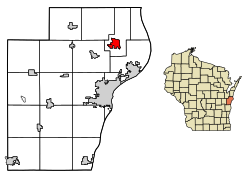
 Location of Mishicot in Manitowoc County, Wisconsin | |
| Coordinates: 44°14′17″N 87°38′28″W / 44.23806°N 87.64111°W | |
| Country | |
| State | |
| County | Manitowoc |
| Established | 1847 |
| Area | |
• Total | 2.60 sq mi (6.73 km2) |
| • Land | 2.55 sq mi (6.61 km2) |
| • Water | 0.05 sq mi (0.13 km2) |
| Elevation | 627 ft (191 m) |
| Population | |
• Total | 1,442 |
• Estimate (2019)[4] | 1,388 |
| • Density | 544.10/sq mi (210.12/km2) |
| Time zone | UTC-6 (Central (CST)) |
| • Summer (DST) | UTC-5 (CDT) |
| ZIP code | 54228 |
| Area code | 920 |
| FIPS code | 55-53350[5] |
| GNIS feature ID | 1583731[2] |
| Website | www |
Mishicot is a village in Manitowoc County, Wisconsin, United States. The population was 1,442 at the 2010 census. The village is adjacent to the Town of Mishicot.
- ^ "2019 U.S. Gazetteer Files". United States Census Bureau. Retrieved August 7, 2020.
- ^ a b "US Board on Geographic Names". United States Geological Survey. October 25, 2007. Retrieved January 31, 2008.
- ^ Cite error: The named reference
wwwcensusgovwas invoked but never defined (see the help page). - ^ Cite error: The named reference
USCensusEst2019CenPopScriptOnlyDirtyFixDoNotUsewas invoked but never defined (see the help page). - ^ Cite error: The named reference
GR2was invoked but never defined (see the help page).